The Parish of Anwoth.
Placenames
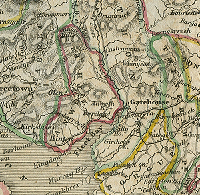
The placenames index for this parish is accessed via the menu on the left. Links from there open up access to various historical and modern maps indicating where the place is to be found as well as links to other historical information and photographs if we have them.
References
Extensive historical information, particularly in the form of scanned books, is becoming available on the Internet.
In this section we have begun listing links to this information relative to this parish.
Old Postcards
Thanks to a Victorian hobby of collection topographical postcards many old views from within the parish are available today. This section contains an ever growing
selection from those we have available.
Flickr Galleries
Below the map on the right of this page, there is a series of links to the Flickr website.
Each link gives access to a gallery of images submitted to that website by members of the public on the specified place/topic relating to this parish. We are very grateful to the contributors of the images contained in the galleries for setting permissions for use in this way. They greatly compliment and enhance the content of our website.
A TOPOGRAPHICAL DICTIONARY OF SCOTLAND, by Samuel Lewis. Published in 2 vols, London, 1846.
"ANWOTH, a parish, in the stewartry of Kirkcudbright ; containing, with part of the burgh of barony of Gatehouse, 883 inhabitants. This parish is bounded on the south by Wigton bay, on the south-east by the bay of Fleet, and on the east by the river Fleet, which separates it from the parish of Girthon. It is about 6 1/2 miles in length, and 2 1/2 in breadth, comprising an area of 10,500 acres, of which nearly one-half is arable, and the remainder meadow and pasture. The surface, near the sea-shore, is generally flat, and, towards the north, rises into hills of various elevation, of which the highest, Cairnharrah, partly in this parish, but chiefly in that of Kirkmabreck, is 1100 feet above the sea, and commands an extensive view, embracing the Isle of Man, part of Cumberland, and the coast of Ireland. The river Fleet, which has one of its sources in a small loch of that name, in the parish of Girthon, after receiving various tributary streams, falls into the bay of Fleet, from which it is navigable, for about three miles, to Gatehouse ; salmon, sea-trout, and flounders are found in this river, but not in any great quantity.
The soil on the coast is dry and fertile, and in other parts thin and light, but has been much improved by the use of lime, which is brought from Cumberland, at a moderate cost ; marl, also, is found in the parish, and a great abundance of shells on the sea-shore, which are likewise used for manure. The chief crops are oats and barley, with some wheat, and potatoes, of which large quantities are sent to the ports on the Clyde, and to Whitehaven and Liverpool ; the system of agriculture has been greatly improved ; the lands have been well inclosed, and the farm-houses and offices are generally substantially built. The cattle are mostly of the black native breed, and the sheep, for which the moorlands afford good pasture, are principally of the black-faced kind ; considerable numbers of both are reared in the parish, and sent to the English markets. There are some large tracts of ancient wood on the banks of the river, and in the grounds of the principal landed proprietors ; and the plantations, which are of oak, ash, birch, and fir, are also extensive, and in a thriving state. The rateable annual value of the parish is £3717. The principal mansions are, Cardoness, which has been rebuilt within the last twenty years ; and Ardwall and Rusco, which are of older date. The road from Carlisle to Port-Patrick passes along the southern border of the parish ; and the river Fleet, of which the navigation has been greatly facilitated by the construction of a canal, by Mr. Murray, of Broughton, affords facility for coasting vessels bringing supplies of coal, lime, and various kinds of merchandise, and for the transport of cattle, sheep, and agricultural produce.
The ecclesiastical affairs are under the superintendence of the presbytery of Kirkcudbright and synod of Galloway ; the minister's stipend is £230. 15. 2., with a manse, and a glebe valued at £10 per annum; patron. Sir David Maxwell, Bart. The church, erected in 1826, at a cost of nearly £1200, is a neat structure, with a tower at the west end surmounted by a spire, and contains 400 sittings. There is a small place of worship for Burghers. The parochial school is well attended ; the master has a salary of £34. 4. 4., with a house and garden, and the fees average £20 per annum. The only remains of antiquity are, the Tower of Rusco, and the Castle of Cardoness, both on the river Fleet, the former two miles above where it ceases to be navigable, and the latter beautifully situated near its mouth ; they are quadrilateral structures, apparently of great strength, but nothing is known of their origin or history. On the summit of a hill to the south-east of the church, are the remains of a vitrified fort, 300 feet above the level of the sea, and defended, where most easily accessible, by a double fosse ; near the spot, have been found several silver coins of Elizabeth, and one of Edward VI. "