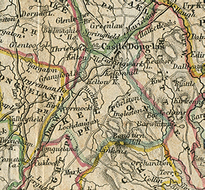
Click map to enlarge
Flickr Galleries
Castle Douglas Streets ![]()
Carlingwark Loch ![]()
Threave Castle ![]()
Threave House & Gardens ![]()
The Parish of Kelton.
Placenames
The placenames index for this parish is accessed via the menu on the left. Links from there open up access to various historical and modern maps indicating where the place is to be found as well as links to other historical information and photographs if we have them.
References
Extensive historical information, particularly in the form of scanned books, is becoming available on the Internet.
In this section we have begun listing links to this information relative to this parish.
Old Postcards
Thanks to a Victorian hobby of collection topographical postcards many old views from within the parish are available today. This section contains an ever growing
selection from those we have available.
Flickr Galleries
Below the map on the right of this page, there is a series of links to the Flickr website.
Each link gives access to a gallery of images submitted to that website by members of the public on the specified place/topic relating to this parish. We are very grateful to the contributors of the images contained in the galleries for setting permissions for use in this way. They greatly compliment and enhance the content of our website.
A TOPOGRAPHICAL DICTIONARY OF SCOTLAND, by Samuel Lewis. Published in 2 vols, London, 1846.
"KELTON, a parish, in the stewartry of Kirkcudbright ; including the villages of Rhonehouse and Gelston, and containing 2875 inhabitants, of whom 1848 are in the town of Castle-Douglas, 10 miles (N. E. by E.) from Kirkcudbright. This parish derives its name, of Celtic origin, from the extensive woods formerly in its vicinity; and is bounded on the west by the river Dee, which separates it from the parishes of Balmaghie and Tongland. It extends nearly six miles in length, and is about three miles in average breadth, comprising an area of almost 11,400 acres, of which 3000 are arable, 560 woodland and plantations, and the remainder moorland pasture and waste. The surface rises gradually from the river into a ridge of hills of conical form, most of which are arable to the summit, and which, towards the south, increase in loftiness till they attain, in some parts, an elevation of 1200 feet above the level of the sea. The highest of these hills are, Bengairn, the Skreel, and Dungyle : from the two former is obtained an extensive view embracing the whole vale of the Dee, the hill of Cairnsmuir, the mountain range that separates the county of Kirkcudbright from Ayrshire, St. Bees Head, and the Cumberland hills. The river Dee, which here attains its greatest breadth, divides into two streams above and below the bridge, inclosing two large and beautifully wooded islands; and several rivulets, descending from the hills, intersect the parish in different directions. The Slack burn and the Auchlane burn, which have their rise in Bengairn, after flowing for some distance towards the north, take a western direction, and fall into the Dee. Three other burns descend from the Skreel, of which one, taking a northern course, flows past the village of Gelston, into Loch Carlinwark, and the other two run south-easterly into the Solway Frith. The loch of Carlinwark, situated in the north angle of the parish, was originally 180 acres in extent; but in 1765 it was partly drained by the construction of a canal, one mile and a half in length, which, conveying its water to the Dee, reduced its height to the same level, and diminished its surface to 100 acres. By the draining of the lake, great quantities of rich marl were obtained, and, being carried by the canal to the Dee in boats, was shipped to many of the surrounding parishes for the improvement of the lands.
The Soil is mostly a thin hazel loam, or brown mould, mixed in some places with sand, and in others incumbent on gravel and a stiff retentive clay, but generally fertile, producing abundant crops of grain, with potatoes and turnips, and the various grasses. The system of agriculture has been greatly improved under the encouragement of an agricultural society comprising Kelton and the adjacent parishes, in each of which ploughing matches take place by turns ; and a general shew of stock is held annually, at Castle-Douglas, on the first Tuesday in October, when prizes are awarded. The farm-houses are substantially built, and roofed with slate; the lands have been much enriched by the marl from Carlinwark loch, and are inclosed partly with stone dykes, aud partly with hedges of thorn; bonedust is used as manure for turnips; and all the more recent improvements in the implements of husbandry have been adopted. The moorlands afford good pasture for black-cattle, of which considerable numbers are reared : and though none of the farms are exclusively appropriated to the purpose, numbers of sheep, chiefly of the black-faced, with a few of the Leicestershire and Cheviot breeds, are fed on the several lands. There is no established fishery; but salmon are taken in the Dee, and trout, pike, and perch in the loch, which is also frequented by almost every variety of water-fowl. The substrata are chiefly greywacke and slate, with veins of porphyry; and granite is found in the hills. The plantations, most of which are of modern growth, consist of oak, ash, elm, larch, and Scotch and spruce firs, and are in a very thriving state. The rateable annual value of the parish is £9170. Gelston Castle was built by the late Sir William Douglas, and is conspicuous for the elegance of its architecture, and the romantic beauty of its situation. Carlinwark, erected by the late Mr. Mc Culloch, and Daldawn, built by the late proprietor, Captain Mc Dougall, are also handsome mansions. The village of Rhonehouse, on Kelton hill, was long celebrated for its annual fairs for cattle and horses, all of which have been removed to Castle Douglas, except the June fair, which is still held at Rhonehouse, chiefly for horses and for hiring servants. There are no manufactures of importance; but a few of the inhabitants are employed in hand-loom weaving for the houses at Carlisle. Facility of communication is afforded by good roads, of which the military road from Carlisle to Portpatrick passes through the northern part of the parish for about four miles, and others intersect it in various directions.
The Ecclesiastical affairs are under the superintendence of the presbytery of Kirkcudbright and synod of Galloway; and the parish includes the ancient parishes of Gelston and Kilcormack, which, after the decay of their churches, were annexed to it about the year 1689. The minister's stipend is £246. 18., with a manse, and a glebe valued at £20 per annum ; patron, the Crown. The present church, a plain substantial structure with a campanile turret, was erected on a more eligible site than that of the old edifice, in 1806, and has since been enlarged by the addition of galleries ; it now contains 1000 sittings, but from the rapid increase of Castle-Douglas, it is quite inadequate to the wants of the parish. There are places of worship for members of the Free Church, Reformed Presbyterians, and the Relief. Three parochial schools are supported, of which the original is at Rhonehouse, and the two others respectively at Gelston and Castle-Douglas: about 440 children are instructed. The master in Rhonehouse has a dwelling-house, and one-third of £51. 6., paid by the heritors, with £2 from a bequest by Sir William Douglas, and £7. 10. from the seat-rents of the galleries in the church. The master of Gelston receives nearly the same income, but has no dwelling-house; and the fees in each of the two schools average £32. The master at Castle-Douglas has one-third of £51. 6., £7. 10. from Sir William Douglas's fund, and £15 from seat-rents, in addition to the fees, which average £120 per annum. There are three other schools, for females, unendowed, but of which the teachers, besides their fees, receive a small sum from the Douglas fund. Miss Harriet Douglas bequeathed £100, of which the interest is distributed in coal among the poor. The parish contains numerous remains of antiquity, among which is part of a Druidical circle on the farm of Torrs. There are several British forts, of which two are in good preservation, on the hill of Dungyle, and both defended by three ramparts of stones and earth; the one has a circular area of 117, and the other of 68, paces in diameter. In a tumulus near Gelston, have been found a stone coffin containing human bones of gigantic size, a copper helmet, and some military weapons greatly corroded. At Mid Kelton, a Roman tripod has been discovered by the plough ; and on an island in Carlinwark loch, has been found a large iron hammer, supposed to have been used by the Druids. Several canoes; a Roman dagger, plated with gold, and twenty-two inches long; the remains of an iron forge said to have been employed by the troops of Edward I. for shoeing their horses; and various other relics, have also been discovered in the loch.